Rum River Geocaching

This may help you plan a trip down the Rum River to do some geocaching. The following is a listing of launches/landings, following a down-river path. I do not recommend trying to paddle up-river in most cases, plan for two vehicles/landings if that is your mode of transporation.

Travel times are not listed because they will vary between paddling strength, boat speed, etc. Personally, I estimate 20 minutes per mile, roughly, paddling in a kayak. Distances are as the river flows, not as the crow flies.

Cache counts are approximate due to new/archivals, hidden waypoints not accounted for, and whether you go after the non river-based caches while in the area.

Legs that contain rapids are not recommended to do with a motorized boat! Even legs that do not contain rapids can still have shallow spots, fast/unpredictable currents, and large rocks.


Rum River Status Reports

bnelson333 | 05/26/2019 04:26 PM
I was on the Rum today between Timber Rivers and Strootman, VERY high and fast, goose poop island completely under water

bnelson333 | 04/14/2019 06:28 PM
On the Rum today. Water is a little high and a little fast but not too bad. Can still paddle against the current just fine.

bnelson333 | 05/19/2018 08:12 PM
On the Rum today near Rum River Central Regional Park and it was much lower and slower than a few weeks ago

Mn-treker | 04/28/2018 03:55 PM
Today I went to Martins landing in Isanti. The river has risen very high now. Parking lot is 1/4 covered in water. This puts river about 5 feet above normal flow.

bnelson333 | 04/03/2018 01:10 PM
On 4/1 the water was open, with lots of pockets of slushy surface ice and icy shore shelves, water is normal level

Make a Report
Name | Report | Key |
You must know the key in order to make a report, this is to stop spam. If you would like to be able to make reports, please contact me through my contact link at the bottom of this page.

Rum River Funtastic Series + Spirit River Series:

LegFromCoordinatesToCoordinates# CachesDistanceNotes
AMartin's Landing Boat LaunchN45 29.298 W93 16.003Anderson Park Boat LaunchN45 26.547 W93 18.380204.0 miles1, 2
BAnderson Park Boat LaunchN45 26.547 W93 18.380County 10 Carry-InN45 25.290 W93 19.744142.6 miles2, 3
CCounty 10 Carry-InN45 25.290 W93 19.744End of Rum River Funtastic SeriesN45 24.315 W93 21.761 142.2 miles4, 5, 6
DEnd of Rum River Funtastic SeriesN45 24.315 W93 21.761 Rum River North ParkN 45 23.338 W93 21.50402.5 miles7, 8

Notes
1 - This doesn't include the five caches in the park by the Martin's Landing Boat Launch.
2 - Anderson Park Boat Launch is sometimes closed due to flooding/hunting.
3 - If you are only concerned with the Spirit series (skipping the Funtastic series) and want to get the four caches North of the launch, it will add 1.3 miles round trip (instead of the 4 mile paddle coming from the launch North of here).
4 - This doesn't include the six park based caches that are possible to get if you dock the boat on the shore, or get before leaving the launch.
5 - May need to go back up-river and either land at County 10 landing or Rum River Drive boat landing, or continue on to the next leg, which doesn't have any caches.
6 - It is possible to add one cache to this count by going up to the road on foot after landing.
7 - Rapids are present in this leg.
8 - There aren't any caches here (yet?), but if you want to connect the Spirit Series to the next series, this is what it adds.


St. Francis to Ramsey Route:

LegFromCoordinatesToCoordinates# CachesDistanceNotes
ERum River North ParkN 45 23.338 W93 21.504River Meadows Park Boat LaunchN45 21.810 W93 21.56262.8 miles1, 2
FRiver Meadows Park Boat LaunchN45 21.810 W93 21.562Viking Blvd Carry-InN45 19.665 W93 22.42153.9 miles1, 3
GViking Blvd Carry-InN45 19.665 W93 22.421Rum River Central Park Boat LaunchN45 17.791 W93 22.62022.75 miles1, 3, 4
HRum River Central Park Boat LaunchN45 17.791 W93 22.620Rum River Central Park Carry-InN45 17.423 W093 22.80823.2 miles5, 6
IRum River Central Park Carry-InN45 17.423 W093 22.808Timber Rivers Park Carry-InN45 16.717 W93 24.34121.9 miles1, 4, 6
JTimber Rivers Park Carry-InN45 16.717 W93 24.341Strootman Park Carry-InN45 14.994 W93 22.94233 miles7
KStrootman Park Carry-InN45 14.994 W93 22.942Brom Carry-InN45 13.394 W93 23.41852.8 miles


Notes
1 - Rapids are present in this leg.
2 - If you don't want to paddle through the rapids to the South of Rum River North Park Carry-In (near the bridge) or you are trying to come back up and can't make it through, you can go to the East bank, portage the peninsula, and get back in calmer water.
3 - The rapids near Viking Blvd are very strong and maybe not possible to paddle through. If going up river, you may need to get out and wade through it. Be aware of slippery rocks and quick drop offs! If coming down river and landing here, I suggest hugging the West shore. The current is slower, has less rocks, and is shallow enough to get out and walk if needed.
4 - These three caches are actually easiest to get right from Rum River Central Park Boat Launch. Paddle up for two, paddle down for one, then go back to the launch and transport to elsewhere.
5 - It may be easier to portage from launch to launch in this park.
6 - There is also an unofficial carry-in access point just to the West of the Rum River Central Park Carry-In, where 7th crosses the river. Some might choose this because no parking permit is required, but there is less parking.
7 - It is slightly shorter to paddle up-river from Strootman, get the caches, and come back (2.2 vs 3 miles).


Google Map
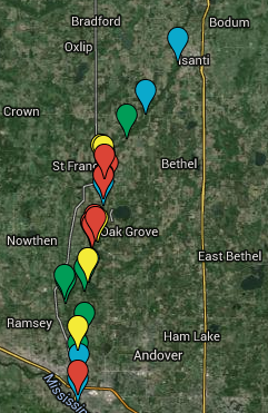
Click on the image or this link for a Google Map that I have created that shows all boat launches, and known hazards. Be aware that more or less hazards may actually be present, depending on water level, time of year, etc.

Teal - Boat Launch
Green - Carry-in access (canoes/kayaks only)
Yellow - Possible hazard
Red - Known hazard
Orange - Misc information


This website is maintained by bnelson333
Hit Counter: 2533